
The sea level is not likely to rise by the 100 meters shown in the map above ever. This is probably more than the maximal amount it could rise is all of the ice caps on the planet melted (which is about 58 meters and would take centuries, or even thousands of years, to happen). If all of the ice caps melted, it would look like this:

But global warming is likely to cause sea levels to rise somewhat (perhaps two to three meters by the year 2100), and it is also likely to cause storms and peak flooding coinciding with high tides to become worse. In that case it would look like this:

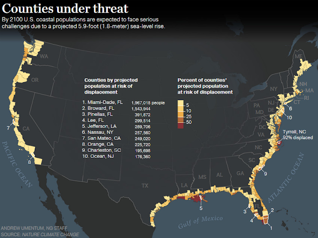
The counties in the U.S. affected by 2100 (with only a two meter sea level rise) would be:

Even when places are not actually underwater all of the time, places that are less than 100 meters above sea level are still facing an elevated risk of natural disasters like serious storms (including but not limited to hurricanes and tornados) and floods for the foreseeable future. And, the places that will be hardest hit are easy to identify as places at an elevated risk, due to their low elevation.
What is likely to happen?
According to the U.S. National Oceanic and Atmospheric Administration (as of 2022):
Sea level along the U.S. coastline is projected to rise, on average, 10 - 12 inches (0.25 - 0.30 meters) in the next 30 years (2020 - 2050), which will be as much as the rise measured over the last 100 years (1920 - 2020). Sea level rise will vary regionally along U.S. coasts because of changes in both land and ocean height.Sea level rise will create a profound shift in coastal flooding over the next 30 years by causing tide and storm surge heights to increase and reach further inland. By 2050, “moderate” (typically damaging) flooding is expected to occur, on average, more than 10 times as often as it does today, and can be intensified by local factors.Current and future emissions matter. About 2 feet (0.6 meters) of sea level rise along the U.S. coastline is increasingly likely between 2020 and 2100 because of emissions to date. Failing to curb future emissions could cause an additional 1.5 - 5 feet (0.5 - 1.5 meters) of rise for a total of 3.5 - 7 feet (1.1 - 2.1 meters) by the end of this century.
UPDATE with Bonus content:
The images below are basically impossible but worth of considering for fantasy and science fiction worlds.
At 200 meters of sea level right, the Northeast Corridor and the greater Mississippi Valley are inundated and California and Oregon have impressive inland seas:

At 400 meters of sea level rise, the Eastern U.S. has been reduced to an island chain and Washington and Oregon share a major, far inland sea:

This is what it looks like when the Las Vegas strip has oceanfront beaches nearby and the Appalachian mountain chain starts to resemble New Zealand or the Philippines:

It would look like this when beachfront property was available not far from Denver - all of the Eastern U.S. and most of the land in the Pacific states is underwater at this point:

4 comments:
Wild variations in predictions for near and slightly longer term sea level rise. There is no way to predict it. But one question I have is how about long term.
Latest long-term projections I have seen are that the current warm interval may last 50,000 years! How much ocean expansion from warming of the water is even possible? I have no idea. A slight rise in temps from current levels will mean ongoing, if slow, sea level rise. How much is potentially possible, over 50,000 years?
My own bias is that the easily and quickly meltable ice is pretty much already gone, and what is left on Greenland and especially Antarctica is a lot harder to melt off. Estimate for total sea level rise if it all melted is about 150 metes, per Wikipedia, which is very unlikely in any near-term scenario. But I keep thinking about that 50,000 years of warmth.
"Wild variations in predictions for near and slightly longer term sea level rise. There is no way to predict it."
The fact that a prediction has some quantifiable amount of uncertainty doesn't mean that you can't make a prediction. It just means that there are well defined limits to how precisely accurate that prediction can be. And, the variations for the near and slightly longer term aren't that huge. The worst case uncertainty spread is on the order of 2 meters of sea level rise over 75 years and even if you increase that by say 50% for a fudge factor and unknown systemic error, it still isn't that huge of a difference, even though the worst case scenario and the best case scenario differ by roughly a factor of ten if you include that fudge factor. For many purposes, that level of precision is more than sufficient.
You get to 58 meters of sea level rise by melting off all current ice caps (which is very simple math with high precision). The maximum rise in temperatures over 50,000 years would impact sea levels beyond that 58 meters is only modestly greater, probably still less than 100 meters, although the exact calculation is challenging.
Water temperature itself doesn't impact the volume of an ocean all that much, and even over 50,000 years of rising air temperatures, the temperature of deep ocean water doesn't change very much relative to the far more significant changes in the surface temperature of the water. So, big water temperature changes are restricted to a fairly small percentage of all ocean water.
Higher air temperatures would melt glaciers and snowcaps on inland mountains that are not included in the 58 meters and could evaporate fresh water lake and river water which would disproportionately rain back down into the oceans. But that doesn't have a huge magnitude impact since there isn't all that much inland surface and ground water.
Also, higher temperatures would tend to increase the global average air humidity which would slightly lower sea levels, counterbalancing the other effects, although probably with a far smaller effect magnitude.
I think you are making a foot v. meter unit error regarding the Wikipedia ice cap melt prediction. The article (which is linked in the post above) states:
"The available fossil fuel on Earth is enough to ultimately melt the entire Antarctic ice sheet, causing about 58 m (190 ft) of sea level rise."
Wikipedia's source for this statement is:
Winkelmann, Ricarda; Levermann, Anders; Ridgwell, Andy; Caldeira, Ken (11 September 2015). "Combustion of available fossil fuel resources sufficient to eliminate the Antarctic Ice Sheet". Science Advances. 1 (8): e1500589. Bibcode:2015SciA....1E0589W. doi:10.1126/sciadv.1500589. PMC 4643791. PMID 26601273.
I've always wondered how much sea level rise it would take to push the salt water line back in the St. Laurent estuary all the way back to Montreal.
Post a Comment